Cheshire and Warrington Local Nature Recovery Strategy
Overview
After more than two years of hard work, Cheshire West and Chester Council are happy to share that Cheshire and Warrington’s first ever Local nature recovery is now published. Thank you to all of the organisations and individuals who helped in developing this key document. The strategy is a fully comprehensive, holistic, collaborative document that looks to reverse decades of nature's decline within Cheshire and Warrington.
You can now view the final strategy documents and the Local Habitat Map by following the links below.
About Local Nature Recovery Strategies
Local Nature Recovery Strategies are a set of new spatial strategies that look to develop the concept of the nature recovery network to reverse the decline of nature across England. They are intrinsically linked to Biodiversity Net Gain and will have links with Environmental Land Management schemes.
The Local Nature Recovery Strategy for Cheshire and Warrington covers West and East Cheshire, the Dark and South West Peaks of the Peak District National Park and Warrington Borough. It is a long term plan that is being delivered through the work of key land owners and managers, local residents and communities, local authorities and a range of organisations and businesses operating in Cheshire and Warrington.
The Local Nature Recovery Strategy Local Habitat Map
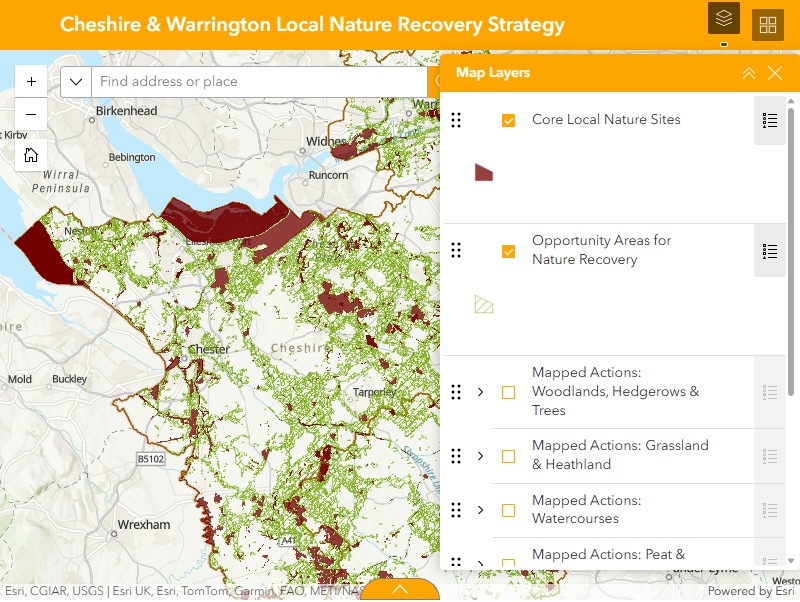
The Local Habitat Map (shown below) demonstrates the strategic nature recovery network for Cheshire and Warrington. This map identifies the best opportunity areas for nature recovery in between the designated and non-designated sites (core nature sites). Within the opportunity areas, there are mapped actions available for different habitats, that have been identified as the specific actions that can create, restore and enhance nature within these areas.
The map is not prescriptive but provides relevant information to enable everyone to deliver the best outcomes for nature for a location. This map informs Biodiversity Net Gain delivery and will be helpful in delivering Environmental Land Management schemes, subject to further government updates in 2026.
Unmapped actions mentioned in the document can also be used to deliver relevant necessary outcomes looking to be achieved in appropriate locations.
The user guide and FAQ sheet for the Local Habitat Map can be found here:
To view the appendices, which include further technical information relating to the LNRS, please see the Cheshire Local Nature Partnership website.